The Madaba mosaic map, presently in the Greek Orthodox Church of George, is the oldest pictorial map of the Holy Land. The map is part of a mosaic floor within an old Byzantine church. The map dates back to the second half of the sixth century AD, and describes the eastern Mediterranean region in the Byzantine era, with the city of Jerusalem as its center. It also shows several sites in Palestine, Jordan, and part of the neighboring countries, i.e., Egypt and southern Syria.
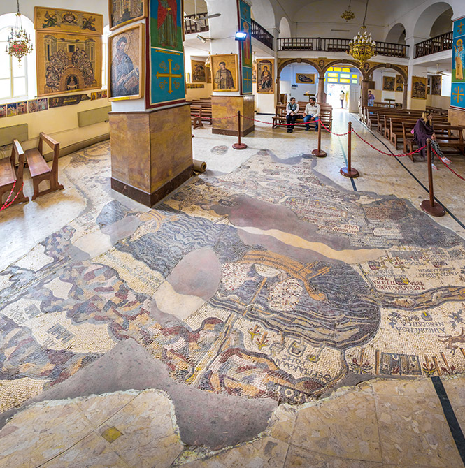
The Madaba mosaic map, found in the Greek Orthodox Church of St. George, is the oldest illustrated map of Jordan, Palestine, and Egypt. With mentioning of the names of cities, historical places and rivers. Scholars believe that this map dates back to the second half of the sixth century, due to the similarity of its art and the mosaic art of the Church of the Apostles by the artist Salamian (Suliman), in addition to that it mentions the New Church of the Virgin in Jerusalem, which was inaugurated in the year 543 and is the most recent building mentioned in this map, because that it is believed that it was established in the year 565.
The map ends in the south of the Nile Delta, and in the north, it reaches Sarfat (Sarafand), while in the west it reaches the Mediterranean Sea, and eastward to the city of Kerak only, because the place of the choir of chanters in the church that annexed it occupied the section adjacent to it. The map occupies a certain place from south to north, and is divided by two columns. So, it was estimated that the original long of the map was 24 meters and its wide is 6 meters.
The map includes Palestine and Jordan, and a part of the neighboring countries, that is, Egypt and southern Syria. It is the map of the holy Jordan, placed on the light of the Torah and the Bible, it mentioned the tribes and made the holy city of Jerusalem a center for it, and it mentioned many of the places mentioned in the Bible, especially in the Gospel of John, and it provided full information about the Byzantine days.
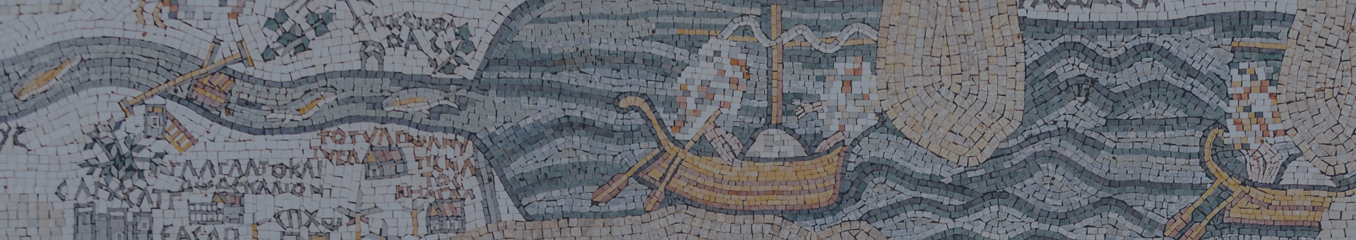
As for the places mentioned and drawn by the map, the artist chose them, either because they are important cities located on the main roads, or because of the accidents that took place in them. The map also represented the nature of the country with its mountains, seas and rivers, because of its importance, and added human scenes, pictures of ships, animals, fish and plants, to fill the void and revive the map itself.
The artist was also keen to highlight the feature of the main cities. In Jerusalem, for example, in addition to the Church of the Holy Sepulcher, he highlighted Bab al-Amoud and the two main streets. In Lod, the most prominent of the Oval Square, and in Kerak, he highlighted the high rock. He also highlighted the various churches, valley swamps, dams in Al-Zara, and two passages on the river of Jordon...
The ruin of the map left us with only a few words that spoke of its era. We find inscriptions on it indicating that it was an offering: "...from the people of Madaba, this is the love of Christ..." Today, we stand before what remains of this map, which assures us that the people of Madaba, at the height of their ancient glory, wanted to present to us (the son of the future) an eternal image of their love for Christ in those mosaic paintings that display our holy country with its sanctities, mountains, and plains that God loved and prophets and saints passed through, sanctified by Christ himself with his presence, and for the churches that recall the most important events of the authentic Christian faith.